The study of the formation of the Melanesian Border Plateau, led by geochemist Kevin Konrad from the University of Nevada, Las Vegas, has challenged the way in which it is believed that such plateaus originate, showing that it did not form all at once but rather needed several phases. This plateau is located to the east of the Solomon Islands in the Pacific Ocean, and its growth continues unabated today. When these formations originate from a single flood of magma, they are known as large igneous provinces, but this is not the case for the Melanesian.
In 2013, Konrad and his team were able to study the Melanesian border plateau for 5 weeks with the aim of answering what the phases of its creation were. The study of the ages and chemistry of rock samples revealed that its formation can be traced back to 120 million years ago. It is believed that Robbie Ridge, a portion of the plateau, formed after a huge flood of basaltic lava. 45 million years ago, the Pacific hotspot, which rises from the mantle causing the formation of volcanoes, explains the origin of the Hawaiian islands.
In the case of our plateau, it was not just a hotspot, but also the Rurutu-Arago hotspot, located under French Polynesia, was added. It was then that a series of islands were formed that eroded and disappeared 13 million years ago, but the submarine mountain floated over the Samoa hotspot. In the last three million years, the movements of the Tonga Trench led to volcanic eruptions on the plateau, quite different from what had occurred until now.
Given the results of this investigation, both the National Oceanic and Atmospheric Administration (NOAA) and the non-profit organization Ocean Exploration Trust are collecting samples from these seamounts in the United States. The next mission of Konrad and his colleagues from the University of Maryland and California State University, Long Beach, is expected to take place soon, as it will involve collecting samples from more Pacific mountains that they believe may have resulted from overlapping hotspots.
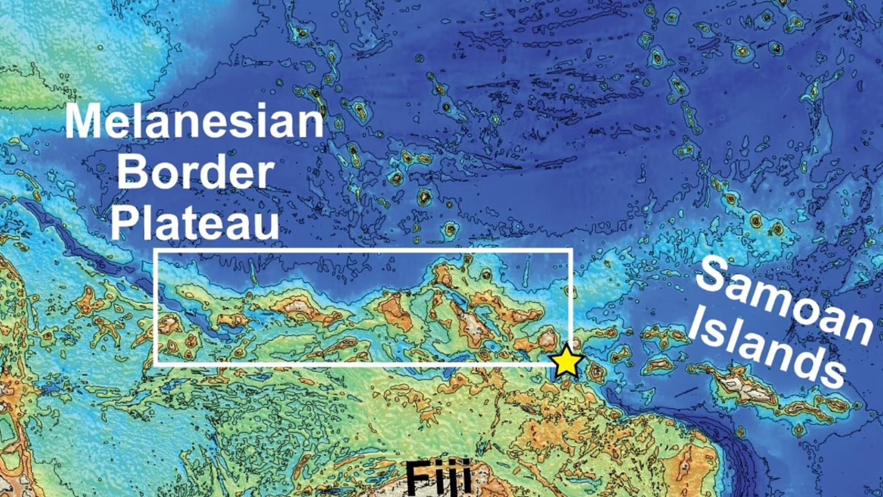
Melanesian Border Plateau
With an area of 222,000 km², the Melanesian Borderland Plateau represents a large geological structure located in the Pacific Ocean, along the northeastern edge of Melanesia. Its origins are attributed to the Cretaceous period, but its formation has taken place over millions of years and continues to this day. It is composed of seamounts, ridges, and guyots, which are underwater mountains with flat tops. Its origin lies in the actions of tectonic plates and volcanic hotspots, which gave rise to this igneous province.
Phases of its formation
It was thanks to the research work of geoscientist Kevin Konrad from the University of Nevada, Las Vegas, that a clear timeline has been established explaining the formation process of the Melanesian Border Plateau, which required several episodes to become what it is now.
Cretaceous Period (120 million years ago)
The beginning of its formation corresponds to a basalt flood, which created a plateau that is believed not to have reached the surface. This portion was called Robbie Ridge.
45 million years ago
The movement of tectonic plates caused the plateau to collide with the Rurutu-Arago hotspot, leading to new eruptions that resulted in several islands which, due to erosion, submerged again.
13 million years ago
Another displacement of the plateau brought it to the Samoa hotspot, where magma again rose to the surface, once more creating islands that also ended up submerged due to erosion.
From 3 million years ago to the present
Until now, the eruptions had been due to the action of hot spots. However, the last phase was a response to the tectonic movements of the Tonga Trench, which led to the reactivation of volcanic activity on the plateau.
The importance of this type of research, as well as its results, has led both the National Oceanic and Atmospheric Administration and the nonprofit organization Ocean Exploration Trust to collect samples from underwater mountains in the United States, and for Konrad and his colleagues at the University of Maryland and California State University in Long Beach to continue sampling areas that could be the result of overlapping hot spots.